G-MoN

Description de G-MoN
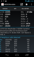
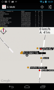
Maintenant LTE prêt! Fieldtest montre LTE RSRP et RSRQ.
Un niveau RXL permanent de-115dBm sur certains téléphones Samsung est un bug Samsung! Seulement Samsung est capable de résoudre ce problème.
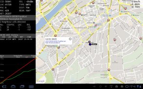
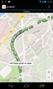
Puissant scanner WarDriving et GSM / CDMA / EVDO / UMTS et LTE Netmonitor et outil de test d'entraînement avec des notifications vocales. Il scanne tous les réseaux WiFi à portée et enregistre les données avec les coordonnées GPS dans un fichier sur votre carte SD. Vous pouvez créer un fichier kml pour Google Earth. Il vous montre la cryptologie, canaliser une force de signal. Il montre tous les points d'accès dans la gamme d'une carte en direct.
G-MON est un scanner de wardriving à collecter et cartographier tous les points d'accès wifi reçues. Il est également un domaine Netmonitor et outil de test drive 2G/3G pour les ingénieurs de planification radio. Besoins activées GPS pour la position correcte sur la carte!
Pour importer une V3.0 (données de la cellule décimal et coordonne sans caractères) fichier CLF, supprimer toutes les lignes de commentaire, renommez-le en import.clf et le copier / sdcard / gmon / puis commencer CLF d'importation à partir du menu.
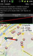
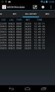
Vous pouvez vous connecter niveaux GSM ou UMTS RX dans un fichier kml pour Google Earth ou un fichier csv. Il ya 5 groupes de couleurs pour les différents niveaux. Ces niveaux peuvent être définis par l'utilisateur dans les paramètres du menu. Ce fichier est enregistré dans le dossier de gmon sur la mémoire sdcard ou externe. Lorsque le journal est en cours d'exécution, la notification Icône G-MON change de couleur rouge. L'exploitation forestière 2G/3G ne fonctionne pas lorsque l'écran est éteint!
G-MoN - Version 4.2.3
(13-01-2020)
G-MoN - Information APK
Version APK: 4.2.3Package: de.carknue.gmon2Ancienne Version de G-MoN
Autres versions


Applications de même catégorie


Vous pourriez également aimer...